DIRECTIONS
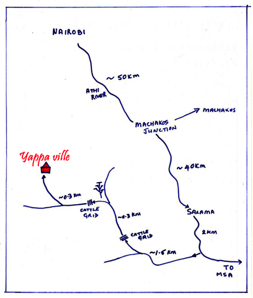
Head out of Nairobi past the JKIA airport and onto the main road that takes you to Mombasa.
You go past Athi River, then Machakos Junction (left) and carry on the main Mombasa Road.
After about 90 km (from Nairobi) you will come to a small town called SALAMA on top of a hill – this is after you have been through some hills where there are obvious climbing lanes on the road.
It is a fairly obvious town, as many of the long-haul lorries stop off here and there are speed bumps. Carry on through Salama for about 2kms – you will be heading down the hill.
Just before the bottom of the hill there is a dirt road on the RIGHT (the ONLY turning once heading down the hill). Take this dirt road (you will have gone too far on the tarmac if you reach the RUBIS Petrol Station at the bottom of hill). Be VERY CAREFUL when turning as the lorries come down the hill very fast behind you!
Once on the dirt road, you will go over a 2nd culvet and a fork in the road approx. 1.5kms in. Take the RIGHT hand fork up over a cattle grid between the RED + WHITE posts - this is not obvious so please keep your eyes peeled on the right side of the road.
At the top of this road there is another fork and a large acacia tree – take the LEFT hand fork over another cattle grid, and then follow the signs to 'OFFICE / KENNELS' (straight and then right up a hill just after a concrete brick building). There is a flat area for parking - please call when you reach here and we will come out to meet you. Do not drive up to our office as we have our own dogs running free and do not want them run over.
On a good day, with little traffic the trip takes about 2 hours max.